STOP Building Blind.
START Building Smart.
Get sub-meter precision terrain intelligence that saves millions in construction disasters. Know exactly where water flows, slopes threaten, and your land hides costly surprises—BEFORE you break ground.
The $1,000,000 Mistake You're About to Make
Every year, developers lose FORTUNES because they built without knowing their land. Houses flood because nobody mapped where storm water actually flows. Foundations crack on "stable" ground that was actually a hidden valley. Road projects double in cost when crews hit unexpected slopes.
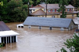
Water Damage
Subdivision developers regularly lose millions when houses flood

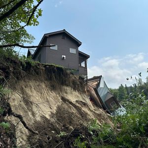
Foundation Failures
Building on wrong slopes costs 5-10x more to fix than prevent
Project Delays
Construction stops dead when terrain surprises emerge

Don't let your next project become a costly disaster
Finally: Terrain Intelligence That Actually Works
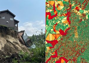
Our terrain analysis gives you sub-meter precision terrain analysis that reveals exactly what your land will do to your project. We map water flow, slope stability, sun exposure, and landform risks with surgical precision—so you build with confidence instead of crossing your fingers.
SPEED THAT MATTERS
Get complete terrain intelligence as soon as data is collected. Your project timeline stays on track.
WORKS ANYWHERE
View projects on your laptop—even offline. No internet required for critical field decisions.
PRECISION THAT SAVES
Sub-meter resolution reveals problems that 10-foot contour maps completely miss.
RISK ELIMINATION
Know where water pools, slopes fail, and foundations crack BEFORE you commit.
Everything You Need to Build with Confidence
WATER FLOW MAPPING
See exactly where storm water travels during floods. Prevent drainage disasters before they happen.
SLOPE ANALYSIS
Know the precise steepness of every surface. Plan foundations and access roads that actually work.
SUN EXPOSURE DATA
Optimize building orientation for energy efficiency. Know which areas get morning vs afternoon sun.
LANDFORM INTELLIGENCE
Identify ridges, valleys, and flat areas automatically. Build on stable ground, avoid problem zones.
ELEVATION PRECISION
Sub-meter accuracy reveals elevation changes other surveys miss. See the micro-topography that matters.
OFFLINE CAPABILITY
Work anywhere, anytime. No internet required when you're making field decisions.
Your Next Project Starts NOW
Every day you wait is another day your competitors get smarter about their land decisions. Every project that starts without terrain intelligence is rolling the dice with millions of dollars.
Early Access: 20% OFF terrain analysis for your first project
Limited to first 100 developers who join our waitlist
Get Your Land Intelligence
Stop gambling with your investments. Get the terrain intelligence that turns uncertainty into profit. Join the developers who build smart, not lucky.